Or: We Didn't Start the Fire
Hahaha, by now you should be thinking hot. What's up with the titles? You'll see.
So, what's a boy to do when the sun is shining and the gas tank is full!?! Hmmmm, what to do!?! Why, let's grab our hats and take off down south to see what might have been!!
Hahaha, you see, back in January/February, we were looking around for someplace we might like to move to. Our two main considerations were #1, location and, #2, the house. We wanted something that excited us about living in it or it excited us about living there. Pretty simple, eh?
In my meanderings around the Net, I found an apartment for rent within my rather limited price range in an old school building in Coos Bay, Oregon. The location wasn't all that great, though, as it sat on the outskirts of the city but the house looked like it would be fun.
What you would get for your apartment was a school classroom along with a kitchenette and a restroom with a shower. It would have been odd, quirky and fun to settle in and make into a home. At least that's what we were thinking. I even made a reservation at the Itty-Bitty Cottages in Coos Bay so we could stay there while we went down to take a look at the old school.
Long story short, before we went down, I stumbled across the listing for the place where we're living now and, as you already know, we took this place.
Still, I've always wanted to go and see that school. I was thinking that, who knows? Maybe in a year or two we'd want to make another change and move on down there.
So, to answer that question: What's a boy to do when the sun is shining and the gas tank is full!?!?!
Road Trip, Baby!!
Hahaha, it is just 127 short miles down to 1400 Pennsylvania St, Coos Bay, OR, and the chance to see what might have been.
And here we go!! Heading out The Jetty on the Road to Adventure.
 |
| CB |
The morning was looking good ... so far.

And while the weather report promised a semi-sunny day when we set out it didn't look all that promising. Course, we did get out early, around 0800.

Hahaha, I like taking road pictures. And I like the pictures I get. It's a big part of the American Scene, the view from the road. I think it is ingrained into the American Psyche, this love of the open road. And what better road to love than Oregon's Scenic Highway, The 101.

And so we cruised down The 101.
I am enjoying my new philosophy about taking my time while driving. I don't mean to imply I don't get upset about delays. I do. Often. And loudly, too.
What I mean is I'm content to set the Cruise Control at the speed limit and motor on down the road seeing as much as I can. And The 101 is prime real estate for seeing as much as you can.

Whup!! THere's the Yaquina Head Lighthouse. From The 101 through the light morning fog. How cool is this, eh!!
Oh, btw, this is Lighthouse #1. Keep reading.

Going south, you get a lot of ocean but as you keep on truckin', you also get some primo forest, too.

Some folks might sa-ay that I'm no good
That I wouldn't settle down if I could
But when that open ro-oad starts to callin' me
There's somethin' o'er the hill that I gotta see
Hank Williams, Ramblin' Man

I know this gets old, but I seriously never get bored with this drive. It's a kick.

Hard to imagine this is a nationally famous highway. It looks more like some back-country road doesn't it? Never gets boring.

And, eventually we pulled into Florence. Now we passed this Taco Bell and then we passed the St. Vinnie's and wanting to stop there just for the heck of it, I hung a Louie, (made a u-turn for you uncool non-60s ((the decade, not my age range) kids) and then quickly decided that Taco Bell would be a grand place to have breakfast and then come back to the Vinnie's.
And so we went to the Bell for breakfast.

Lookin' good, TB.

And we got to meet Robert as he was taking his break.

Robert was in a bad state and needed someone to listen to him and, just a little bit, lift some of his weight up off his shoulders. After some idle chit-chat, we learned he'd just moved up into the Florence area. His friend had lost someone and was lonely and wanted Robert to come back to Florence with him ... and, obviously, he did.
But he didn't have any friends and didn't much like the weather. Oh, Robert was from Long Beach in California and isn't used to having so much rain and clouds and such not. Hahaha, those silly Californians are so spoiled. Nearly every last single one of them. Robert plays football and wants to get back to school so he can play again.
We listened to him and tried to give him just a small bit of advice but, mostly, we listened. He really just needs to realize he's the only one responsible for his happiness. He's just got to make some decisions on what he must do to be happy.
The ball is in your court, Bobby!!

We gave some of our time to Robert but then we had to get on over to St. Vinnie's and then back on the road.
I think it's fun to nose around places like St. Vinnie's or Goodwill. You never know what you'll find and sometimes the surprises are pretty wild. This time, Carol found a skien of yarn. We want to cut it up and lay it about the yard for the birds to use in making their nests.
Hahaha, we're nice like that.

After leaving Florence and going over their ridiculously tall stupid bridge we came down to the Oregon Dunes National Recreation Area. Just another one of the numerous parks along the Oregon Coast. And this one is a biggie.
We made the turn and I followed the road to its end trying to find an easy way to get over these dunes (you know I'm not a fan of going up .... well, it turns out I'm even less of a fan of going up in sand!! Big surprise, right!?!). And I was right because I later learned that just beyond these ominous and daunting dunes were ... another set of dunes, then the beach.

It is a long, long road.

Here's the stupid dunes.

Turn's out that road is nearly six miles long. That's a lot of park there, Buddy!! While we were driving in, we saw three harriers swooping around hunting.
But we made it to the end of the South Jetty on the Siuslaw River.
Fun Facts: The Oregon Dunes National Recreation Area stretches approximately 40 miles north from the Coos River in North Bend, to the Siuslaw River, in Florence.

The Dunes are a unique area of windswept sand that is the result of millions years of wind and rain erosion. These are the largest expanse of coastal sand dunes in North America!! Some of the dunes tower up to 500 feet above sea level (see!! I was right to avoid them!), providing a lot of opportunities for off-road vehicles, hiking and so on.
The really fun fact is that author Frank Herbert was inspired (in part) to write the famous science fiction novel Dune based on his research about the dunes of this area.

Here's the Siuslaw River trying to flow into the Pacific Ocean.

Can you imagine how difficult building this jetty just have been way back a hundred years ago? It required a lot of strong backs since they were just getting into some very rude and crude trucks, etc.

I strolled up the jetty towards the mouth of the river and found this old piece of driftwood.

And, finally, I got to the end of the jetty and was able to see the ocean without having had to climb any stupid dunes.
Hahaha, I win!!

But I did cave in just a little. I went up the nearest dune just to see what was on the other side. Lemme tell ya, it wuz sandy!! Very, very sandy!!

I could use some of this beach grass at our place. And it was all over the place.

Along with these wild strawberry plants.

I can see where these might inspire somebody to write something. Not me.
However, I did feel some inspiration to take a couple of pictures. More than a couple, really.

So, here's the color version. Next you'll get the B&W version. I still try and get some good shots in B&W. I think maybe I equate it to being a real photographer. Y'Know, like if I can shoot something good in B&W then I will be like Ansel Adams.
Hahahaha, as if!!!

And, here's the same shot in B&W. Which one do you prefer?
Me? I always go with a good B&W over color. Now the trick is to get a good B&W.

And what outing would be complete without some flowers. Hey, it's still spring!!

What a kick, eh?

And this. I had walked down to the end of the jetty and then back towards the Mini over the dunes.

When I got back, I found Carol in a good conversation with Steve and Shirley.

They live in Klamath Falls and were up in this area for a car show and a rhododendron show. They're members of a camping organization so they can stay for up to three weeks for free then they have to leave for at least a week and then they can come back. He has a tag-along, a trailer that he pulls.
They take off for a while and then head on back to Klamath Falls. The easy life.

And, neater than neat, when we gave them our business card, they gave us theirs!!
How cool is that!?!?!
Oh, they have two addresses. Go figure. I'm lucky to have at least one that doesn't read, Care of the Sheriff's Department.

After some good conversation, we got back on the road again and headed past some great scenery towards our destination in Coos Bay.


Oh, I've got to do some backtracking here. Remember I counted the lighthouse at Yaquina Head as Lighthouse #1? That's because it was the first one I'd seen today. As we drove into Newport, I could see the top of the Yaquina Bay Lighthouse. That one was Lighthouse #2.
Got it?
OK, because as we were driving down towards Coos Bay, we passed the Umqua River Lighthouse and so we decided to stop by and say hello.
And this one became Lighthouse #3 that I saw today. And this one we actually visited.

And the really odd thing about this one is that it is set on an active U.S. Coast Guard station. The quarters for the Coasties are right next to the lighthouse. Yeah, there's the family base housing right there next to the lighthouse.
I know, weird.
And yet again, I think I should have joined the Coast Guard.

Fun Facts: Located at the mouth of Winchester Bay, the first Umpqua River Light was built in 1855 and lit in 1857. Built along the river channel, the original light was vulnerable to seasonal flooding. This led to yearly erosion of the sand embankment of the light. In October, 1863, the building's foundations had become too unstable and the structure soon collapsed. Before its collapse, the Light House Board decided to built a new light at the location but because of the Civil War, etc., it wasn't until 1888 before Congress approved of construction for the new light.
Construction began on the new light in 1892 and it was first lit in 1894. This lighthouse was built at the same time as the Heceta Head Light and so it was built from the same plans and is virtually identical to its more northern sister.
Unlike its predecessor, the new light had several advantages over the original. Built 100 feet above the river, the new light was safe from flooding. This was partly due to the Light House Board's insistence that ships be able to plot a course based on visible lighthouses. The original light was not visible at sea and was only used as an aid to ships approaching the river.
This lighthouse is 165 feet above sea level and is 65 feet tall.
The original quarters for the Coasties was set about a hundred yards further to the north. But first we had to pass this equipment shed. To the right of the shed is the maintenance building.

And between the maintenance building and the former quarters was this old beauty. I bet she was something else in her day.

This is the back of the former quarters and the entrance to the museum and gift shop.

And here's the stamp published by the U.S. Postal Service. The only one honoring Pacific Coast Lighthouses and guess which lighthouse is featured?
Yeah, you got it!! The Umpqua River Lighthouse.

Fun Facts: The heart of this lighthouse is the 1890 1st Order Fresnel lens, made in France. It stand 100' above sea level, has 2,250,000 candlepower and is visible 20 miles out to sea. Weighing 2 tons, it is 97", 6'2" in diameter, this brilliant jewel shines 24 hours a day from 616 hand-cut prisms and 24 bulls-eyes - 8 of which are covered with red molten glass panels.

And it was a good museum. Interesting exhibits that were well displayed, overall a real surprise.
Nicely done!!

It takes a certain amount of gumption to go to the sea in ships like this.

And use these things to fight with. That first shot better be a good one!!

Hmmmmm, must have been when they were in-between lighthouses.
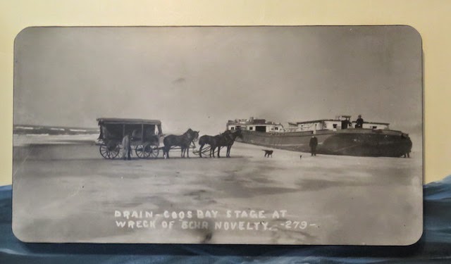
"Drain - Coos Bay Stage at wreck of Schr Novelty - 273 -"
I'm guessing Schr stands for Schooner. The locals waited for low tide to do some traveling between towns as the beach at low tide was the easiest way to get around back then.
Happy employees of the U.S. Lighthouse Service.
Ahoy, Maties!!

Hahaha, I just remembered another reason I wouldn't have been any good as a Coastie then. I wouldn't have ever gone up in the rigging.
Never.
Ever.

It's almost done. Just needs some plaster and then some paint.

And here it is standing tall and looking good. The house to the right is no longer standing. What a shame, eh?

And the second neat surprise was the gift shop.
Again, nicely done, y'all.

Looking good ... if you're into lighthouse night lights.

Lots of nautical stuff to clutter up the house with.


The second floor of the building was for the sleeping quarters. There's four rooms and each room took four Coasties. Not shabby.

Here's the way it looked during WWII.

Then they sorta let it go.
But the historians saved it, thank goodness. Here's the front of the quarters.

Hey, it's still spring, Man.

There's something about the clean lines and symmetry of the older military buildings. They've lost this beauty in modern structures.

They do have tours of this lighthouse but ... (there's always a but, isn't there?) we would have had to wait about 20 or so minutes for the next one and each tour took over 40 minutes. We still had miles to go before our day ended and so I passed on the tour.
But it does look familiar.

Here's the view from the lighthouse ... and the family quarters. It'd be heaven if you were into off-road biking.

There were a number of bikers and off-roaders down there running up and down the dunes.

The light wasn't on but the lamp was still rotating.

And this one was styling with the lighthouse.
 |
| CB |
Soon after, we were on the road again and finally getting close to Coos Bay but first we had to go over another ridiculously big bridge. What's with these guys and their tall bridges, anyway.

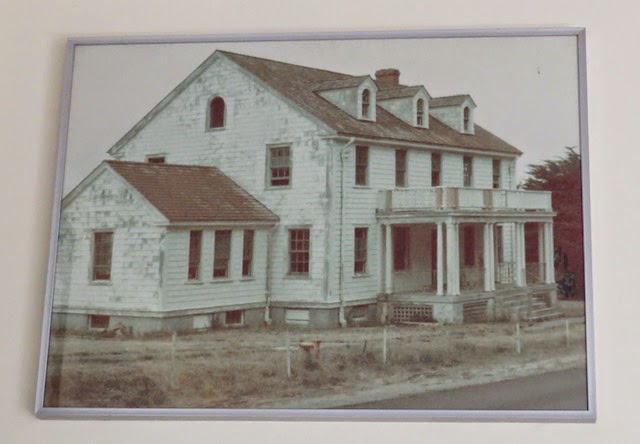
But after the bridge, we had to go through North Bend. We were getting closer to the school that was now an apartment building. Remember, we had thought about moving to this old school house back in January. The idea of renovating an old classroom into an apartment sounded like a lot of fun. And, honestly, how many people can say they live in an old school?
Hahaha, we were getting anxious.

We found the street and made the turn and there was the Old Englewood School...

The damn thing was burned down!!
Now you understand the titles.
Burn, Baby, Burn...

This was the three story auditorium ... or, rather, these are the fire escapes from the auditorium. It was all gone.
Does anybody else see the irony here?

Ta-Da!!
Welcome to your Dream House.

It was a total loss.

So it seems the fire was in December of 2014. I figure we saw a posting that was put up just before it burned down.
Now I have an idea as to why the owner never returned my e-mail queries.
What a freaking surprise this was. Totally.

Well, that wasn't the Happy Ending I was expecting. Honestly, I thought I'd be able to meet the manager/owner and maybe set the stage for the future ... after the beach.
Well, can't change that so we continued on and now we headed towards the Sunset Bay/Shore Acres/Cape Arago State Parks. Yeah, that's right, they have three state parks setting side-by-side along the same stretch of the coast.
What the heck, gotta get something out of this trip. We'd heard from the lady at the museum that they had a lighthouse out this way. The Cape Arago Lighthouse. She said we'd be able to see it just not visit it because it was now on the Indian Reservation and they wouldn't allow any visitors. Seems where it is located is a fragile ecosystem and ... visitors are verboten. But we could see it!!
And we were off.

Again, it was just a beautiful drive. And we drove to the end of the parks. Yeah, the road goes in and then ends in a big loop so it points you back the way you came.

When we got to the end we still hadn't seen the lighthouse. So, we parked and decided to take a look around. As soon as the car door opened, Carol heard the seals arf, arfing in the distance and she was off like The Flash.
I had to take a side trip to the necessary and then I was on my way to the sound of the hounds (aka seals cuz they sound sorta the same).

The barking led me to this path ... down. And, knowing me, my first thought going down the path was that when I returned, I'd have to come back up the path. Argh!!

And still the path went down, down and down.

The coastline here is a bit more rugged than where we live. Hahaha, the rocks are just a wee bit bigger.

And then I finally made it to the end of the trail ... and found Carol in a good conversation with these two.

They were all actively engaged in spotting the seals. Can you see them?

Let's zoom in a bit shall we.
Hahahaha, every time I see them, I feel a kinship with them. They remind me of ... me. I sorta look like this when I hit the couch and I hit the couch often and hard.

Those in the upper picture are primarily Harbor Seals and these, below, are California Sea Lions. And there, on the right in the lower picture, that might be a Stellar Sea Lion.
Bonanza!!

There was a path down to the shoreline but it was closed because the seals were pupping and they couldn't be disturbed.
Oh, ratz!! You mean I can't walk down the path so I could, eventually, come back up the path. Bummer.

Here's the cove that leads out to where the seals are pupping. I used this vista as an excuse to stop for a moment ... just in order to take a picture. Honest.
I'm really not that lazy and out-of-shape that a short walk uphill would faze me. Hahahaha, honest, I'm not!!

A great place for a picnic, eh!?! Everywhere you look, it's a great view.

What a coastline. I'm liking this Oregon thing.

Then we drove back and stopped at another viewpoint ... of the same seals, just from a different angle.
And, naturally, I got just a couple more pictures. Just a few.

California Sea Lions.


Looks like a scene from The Hangover.

Looking up the coast. The Cape Arago Lighthouse is just a mile and a half away from where we were at this viewpoint.

Hola? Mom? Donde esta y'all?

Just a few pictures of the seals. Because they were so interesting as they gamboled together on the beach. See all the activity?

And the last one, honest. It was a lot of fun listening to and seeing them. And, as a bonus, while we were there looking at the seals, we saw a bald eagle flying across in front of us.

So, back in the Mini and we drove along for another mile and a half and then we saw it.
The Cape Arago Lighthouse.

Fun Facts: Starting in the mid-19th century, Coos Bay had become an important shipping point on the west coast. The amount of shipping warranted the building of a light nearby and, in 1864, funds were given to build a light. In 1866, the first light was illuminated. The first tower, which housed a 4th-order Fresnel lens, was just a 25-foot octagonal tower with a skeleton base.
This tower, located at the west end of an island, was connected to the keeper's residence via a 1,300-foot wooden walkway. Because of its location the light was exposed to all the elements along the Pacific and soon needed repairs. Over the next 35 years, much of the station's infrastructure had to be repaired or replaced. During these repairs, they also added a fog signal and a new boathouse.

More Fun Facts: However, the sailor's demanded a better light and in 1909, a second tower was lit. Located higher on the island, the new wooden tower stood 100 feet tall and provided better illumination. Erosion eventually threatened this light as well and, in 1934, the third light was illuminated.
Containing the second light's 4th order lens, the third tower was made from concrete to better withstand the inclement weather of the area. This light shared a basic design with Point Robinson Light in Washington. It was around this time that the first tower, which still stood, was finally destroyed. The second light fared better. The tower was removed and the building was converted into an office.

More Fun Facts: In 1966, the light was automated. Eventually, in 1993, the Fresnel lens was replaced with a modern lens. The light remind a beacon into Coos Bay for the next 12 years until its decommissioning on January 1, 2006. Today, only the third light remains standing, all other buildings having since been demolished. The site isn't open to the public, and the entire area is fenced off. In 2012, the original wood bridge accessing the light was eroded away by the sea.
It was a bigger operation than I thought just from looking at this one, lone building, that is still standing. You can see the bridge in this shot.
 |
| Internet |
I did get me some pictures of the lighthouse.
This was Lighthouse #4 for the day. The fourth one I had seen.

The tip of the island that the Cape Arago Light sits on.

And this is my favorite picture of this lighthouse.

One last shot. You can see that they've removed the light from the tower.
I wonder if they'd consider renting it? It could be fun, right? It definitely has potential.

And walking back to the Mini, I saw these and, what the heck!! It's only spring once this year, right? Hahahahaha, I can't help it.

The older I get, the slower I go and the more time I have to stop and appreciate these.

And I enjoy it. It makes me happy.

Hahaha, now if I could only get some good pictures of them. But they say the important thing isn't the destination but the journey, right?
I've decided that I'm going to enjoy the journey and not worry about the destination.

Hahaha, I lied, again. I did have one more shot of the lighthouse. This was taken from the parking lot.

Pretty soon we were on the road again, heading north back to LCO. And this meant we had to go back over those doggone bridges. Argh, I just don't like them. Too high. Way too high.

On the bridge, the girders make an interesting pattern.
As long as they hold the stupid thing up.
 |
| CB |
And, I guess this is still a work in progress. Or so it appears. A real confidence builder this is.
 |
| CB |
I sure as heck wasn't going to look down.

And the drive back up was just as scenic and nice as the drive down.

And by this time we were hungry. I've been saving this for an appropriate time and, well, I just felt this was the time.
It was, clearly, time for The Sizzler!!

Hahaha, we got in there around 1730-1745 and I could have given any of the people in here a run for the money in a "Who's the Youngest" contest.
Hahaha, seriously, it was like dining in a geriatric ward. We (sorry, Carol) fit right in.

But, hey, I don't look as old as I feel.
 |
| CB |
And, once again, I was so eager to get into my meal that I forgot to get a picture first. It still looks good and, more important, it tasted soooooo, very, very good.

And Carol got a hamburger ... and fries.

Some more of the Over-The-Hill Gang.

Regardless of the age of our fellow diners - and they weren't all that old. There was at least one couple in there that might have been in their 30s and a couple who were well into their 40s. The rest of us? Hahahaha, We'd broken the barrier into our 60th decade a long time ago.
And now we were back on very familiar terrain. I'm getting to know this stretch of the road. And still liking it.

Hitting the 25 MPH zone in Depoe Bay ... home of the World's Smallest Bay

And also home of a number of cheesy tourist shops along the main street ... all 2/5s of a mile of it.

And heading back we're coming into the Taft neighborhood now. Taft is the southernmost of the small cities that all combined to make LCO.
And, this is near the Tanger Outlet Mall near the Oceanlake neighborhood.

And coming up to the Community Center and the Seven Gables.

The speed limit is 30 MPH through LCO and I just couldn't go fast enough to pass that doggone bus.

Coming into the Wecoma neighborhood.

And down 34th Street towards The Jetty.

And so we ended another good day. Hahaha, I was really looking forward to seeing that apartment building. What a kicker that was.
We had a good time and saw seals, harriers, eagles, herons, egrets and whales. While we were at the first lookout staring at the seals, we saw whales surfacing about a 100 yards in front of us. They came up and sorta rolled a bit and then went down. It was the best sighting I've ever had of them.
And we were able to see the Heceta Head Lighthouse on the drive back. That was Lighthouse #5 for the day. Let's see, we saw Yaquina Head, Yaquina Bay, Umpqua River, Cape Arago and Heceta Head Lighthouses. Hahahaha, that's five for the day.
So maybe the building burned down. Obviously, it wasn't meant to be ... at least for us. But we got to see and do a lot of other things.
All in all, it was a good day.
Life is good.
Hooah!!
No comments:
Post a Comment