It's been a busy few weeks and now I am back to some semblance of normalcy. For a while. And what better way to celebrate things getting back to (our) normal than with a drive around and about on an, allegedly, Vehicular Voyage of Discovery.
Besides, it was time for some day trippin', vis-a-vis The Beatles:
She was a day tripper
Sunday driver, yeah
It took me so long to find out
I found out.
It was a beautiful Sunday and we struck out early on our Voyage and I found out. I found out.
With no particular destination in mind, we were on the road. We made vague plans to stop at Baskett Slough and then onto two parks around the Salem area. Somewhere in that plan was a stop for lunch at a small town diner. Also hidden in these amorphous plans was the absolute need to be decidedly flexible...exceedingly flexible.
And we were...flexible. And it all worked out quite nicely. With no particular destination in mind, we arrived at several surprises and a few delights.
First stop, Baskett Slough.
First off, the word "Slough". I have had the toughest time pronouncing it correctly...I always called it a 'sl-ooowwh' and never felt comfortable with it. Then along comes Carol and very easily teaches me it is pronounced as 'slew'. Which, hahaha, blows my mind. I admit, my mind is easily blown away, but this was out of left field for me. "Slew?" Really!?!
First off, the word "Slough". I have had the toughest time pronouncing it correctly...I always called it a 'sl-ooowwh' and never felt comfortable with it. Then along comes Carol and very easily teaches me it is pronounced as 'slew'. Which, hahaha, blows my mind. I admit, my mind is easily blown away, but this was out of left field for me. "Slew?" Really!?!
Alright, I bow to superior intellects and I quickly got on board. Slew it will now be whenever I say it.
Fun Facts: Located about 10 miles west of Salem, it is open farmland near the eastern foothills of the Oregon Coast Range within the Willamette Valley. The Refuge was created in 1965 to help ensure some of the original habitat remains available for species preservation. The Willamette Valley, with its mild, rainy winter climate, is an ideal environment for wintering waterfowl.
The valley was once a rich mix of wildlife habitats with extensive wetlands, meandering stream channels and vast seasonal marshes. Today the Refuge consists of 1,173 acres of cropland, which provide forage for wintering geese, 300 acres of forests, 550 acres of grasslands and 500 acres of shallow water seasonal wetlands and 35 acres of permanent open water. It's wild, it's varied and it's set aside for...drumroll...ever.

And it is always busy. They have a dirt road through it, the Colville Road, that we can drive down. Actually, large parts of the Refuge is active farmland...but you can see where the farmers are cooperating in preserving the land for the migrating wildlife.
And, if you're observant, you can see some of that wildlife while motoring along this road.
Like this guy, a Scrub Jay, taking a break on a telephone wire.

Or this guy, a Red-Tailed Hawk, looking for something good to eat.

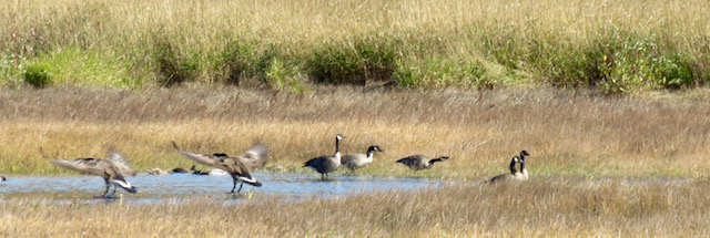
And, of course, the geese.

Like this Canada Goose.
These fellows look so ungainly and, well, clumsy on the ground but up in the air they become almost majestic. While I was driving through Idaho recently, I was treated to a skein of Canada Geese in flight and it was spectacular. I've seen these fat fellows on the ground before but now look at them a bit differently.

Here's a couple of them practicing their synchronized landing skills...These two scored a 9 for that landing...while the others stand around and, well, act like plump geese.
I have been working on my camera skills...and one of those is being able to capture a clear picture of a bird, or birds, in flight. I'm getting there. Plus, I am thinking more and using some of the many tools offered on this amazing camera I have.
Today I was able to see an improvement in my motor skills, in acquiring and actually staying with a moving target and in my technical skills in getting a crisper image. Hooah!! Progress!! Finally!!

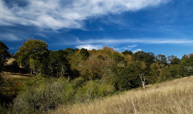
And I still enjoy me a good wide-angle shot with some dramatic sky.
Here's part of the slough looking west across the Colville Road. The 101 is to the south in this picture.

Hahaha, the aforementioned Colville Road.
Which, surprisingly, gets plenty of vehicular traffic...at least while we were there.
They're not there now, but we did see several hawks and a Kingfisher along those telephone poles.

Hahaha, yeah, right. Another wide-angle vista. We will be climbing that huge MOUNTAIN in just a while. Stay with us.

Mind you, I had taken over 900 images today but I culled them down, begrudgingly, to just over 200. And I really pared those down to select just a few for this blog. Breaks my heart...but...you're welcome. Hahaha, just don't come over and innocently ask to see my pictures. You'll be here for a while.

This Great Blue Heron was hunting just a few feet off the side of the road. I tried not to disturb him and took my pictures from the car a bit away. He was obviously hunting.
Fun Facts: GBHs eat fish, frogs, small mammals, reptiles, crayfish, large insects and, occasionally, other birds. They use their long, sharp bill as a spear and will strike downward with great quickness when attacking prey.

They have a couple of trails through the Slough. Helps to keep the folks corralled and entertained at the same time. We drove up a bit further and stopped at one of these trails and took a walk. Unfortunately, it was....up!! Ah, I hate ascents!!

While we were walking along, we saw three deer passing through a field to our right. Here's Mom and Junior.

Looking back towards the parking area at the trail. You can see where the farmer's have worked closely with the Fish and Wildlife Service in maintaining the Refuge.

It was a glorious day. I'm thinking these kind of days will be few and very far between from now until April of 2016. It was even warm out there!!
Follow the yellow dirt road...
That's our destination...Way. Up. There.
ARGH!!

But we made it and it was worth it.
Hahaha, just ask Carol...as soon as she's done scoping out the whole Refuge.

We could even go higher if we wanted.
Hahahahaha!! I know!! I could barely keep a straight face myself when I wrote that!!

But it was worth it...we had a great view. Looking down on the Colville Road.

And across the valley. There are even several homes, or farmsteads, located within the Refuge.

But we had a good time. We were able to spot several birds and had a good walk. But, onto new adventures.
The next stop on our vaguely planned Voyage of Discovery was the Willamette Mission State Park.
I was intrigued by the name of this park. I am a product of the public education system of Southern California in the late 50s and early 60s and so I learned through our California History Studies all about the Missions of California and Father Junipero Serra...you may have heard his name recently as Pope Francis named him a Saint during his recent visit to the States.
I wasn't aware of any Spanish Missions this far north and so I was intrigued enough to want to go on over and take a gander at it and find out what it was all about.

So I plugged the name of the park into my trusty Garmin and took off. Hahaha I was struck by how completely dependent I am on the Garmin to get me from Point A to Point B. I do have an Oregon State Map in the Mini but I rarely every get it out, in this case, rarely = never.
No, I plug in something and then I just follow the arrows. Ah, modern life. I think it can't get any easier but I know I'd be wrong to think like that. They've already got cars that safely drive themselves. It's gonna get a lot better.
So, following Garmin, we tooled along through the beautiful Willamette Valley enjoying the sights of the changing seasons. Not as bold and beautiful as on the East Coast, but Oregon holds its own with colorful foliage during the Fall months.
We're tooling along when we come to a....ferry!!
Yeah, that's what I thought, too!!
Seriously!?! A ferry!?! Today!?!
Yeah, they have one and it's working...well.
Fun Facts: The Wheatland Ferry is a cable ferry connecting Marion County and Yamhill County across the Willamette River. The ferry travels approximately 580 feet across the river.
It's powered by two electric motors connected to an on-board diesel generator. The ferry is supported by two steel cables, one under water on the downriver side and one overhead on the upriver side. It also uses the overhead cable for steering.
Each time a replacement Wheatland ferry is launched, it is always named Daniel Matheny, after the man who originally established the ferry, followed by its number. The current ferry, launched in '02 is Daniel Matheny V. This one differs from the others in that it has a capacity of nine cars rather than the six Daniel Matheny IV carried, and it has its own self-contained diesel-electric generator so it no longer depends solely on electricity from overhead wires.
It operates everyday, weather permitting.
There goes the ferry. We just missed it.

Here's the rates. Passenger cars are $2 and pedestrians are free.

Very quickly the ferry went across and then came back and we were the first ones on.

It doesn't take but a few minutes to make the transit so I didn't get out of the Mini. But I got this shot.

And this one as we neared the other side of the river.
Hahaha, what a kick, eh!?!
Now that's some real Small-Town America!!

We found the park and soon found ourselves walking through a walnut grove. City kid that I am, I did collect a couple of fallen nuts and oohed and aahed over them. In fact, I still have them. Yeah, I know, what a dork!!

After a pleasant walk about a quarter of a mile, we made it to where we could see where the mission had been.
It wasn't a Catholic Mission after all, it was a Methodist Mission.
Fun Facts: The Willamette Mission was established in 1834 by Jason Lee who had traveled to the area to convert Native Americans in the Oregon Country. The missionaries built a one-room house that served as a school, chapel, hospital and living quarters. You can see the vague outline of the structure there on the far side of the pond near the center of the picture.
They later added onto the house and built a barn. In September, 1837, more missionaries arrived and built a blacksmith shop, granary, and a hospital, and a building that doubled as a school and a dining hall.
The mission moved in 1840 to Salem, which was then known as Chemeketa. The original mission site was extensively damaged in a flood in 1861. That's why they have just a 'ghost structure' today to mark the location of the mission.

Hahaha, I likes me some tall trees and blue skies.
Also of interest at this park is the Nation's Largest Black Cottonwood. It's been around for over 250 years!!

And some reflecting waters.
#imasuckaforwaterpictures

We walked around the park. They have equestrian paths and a lot for unloading and loading horses. There were a number of horse trailers there. Plus a place for bikers. We saw scattered throughout the park in a filbert grove, these 'holes' for Frisbee Golf.
Fun Facts: Are Filberts really Hazelnuts? There's truly no wrong answer. 'Filbert' is the correct name for both the tree and the nut. The name is of French origin and filbert trees were likely first introduced into Oregon by early French settlers. Some thought 'filbert' was derived from St. Philibert, as August 22 is dedicated to him, corresponding to the earliest ripening date of filberts in England.
'Hazelnut' is the name coined by the English and applied to the native species by early settlers. In 1981, Oregon decided to conform to common usage and began emphasizing 'hazelnut.'
Regardless of what name you call it, this nut has been revered for centuries. According to a manuscript found in China, around 2838 B.C., the filbert took its place among the five sacred nourishments God bestowed on humans. In olden times, the filbert was used as a medicine and a tonic. More than 1,800 years ago, Greek physician Dioscorides emphasized the properties of the filbert:
"It cures chronic coughing if pounded filbert is eaten with honey. Cooked filbert mixed with black pepper cures the cold. If the ointment produced by mashing burnt filbert shells in suet is smeared on the head where hair does not grow due to normal baldness or to some disease, hair will come again."
Wow!! Who knew!! Hazelnuts can cure baldness!! How can they NOT be touting this feature of the amazing filbert/hazelnut!?!

Soon enough we were on our way again. There were some nice paths to walk along but not much to keep us there at the park. We weren't out for a picnic and so we moved on.
Then I spotted a Sonic Drive-In and it's been a long, long time since I've stopped at one of these so I threw out the plan for a small-town diner and we settled for some fast food with a carhop.
Neither of us were impressed with the food we got. I left thinking I shoulda held out for the diner.
Ratz.

Next up was the Minto-Brown Island Park.
Sounds exciting, eh!?!
Hahahaha, it had a better sound to it than it deserved. Oh, it's a nice park but I didn't see the island and, in fact, we had to work at getting over to the river and then the view wasn't all that grand. It's a good park for bike riders, though. And trees. Tall trees.

Question answered...I was wondering if it were possible to kayak on the Willamette River. Yes, you can.

We didn't stay long. Wasn't much to see and the river walk was so-so.
It was getting late and so we headed on down the road towards home knowing that it would take us, once again, by the Baskett Slough.
And we decided to stop, again.
And we were able to see these guys, some Greater White-Fronted Geese.
Fun Facts: These guys get their name from the distinctive white band found at the base of their bill.
The majority of these geese breed near the Arctic Circle from Alaska to central Canada. They migrate along the Pacific or Central flyways and winter in California's Central Valley, coastal and mid-continent Mexico and coastal Texas and Louisiana.
So they are just passing on through. We saw five geese, two adults and three juveniles, and they stayed closely together the whole time we were there observing.


And, again, I cast a wistful glance towards the MOUNTAIN we had climbed earlier in the day. There it is.
Huge, ain't it!?!?!

While I missed out on getting pictures of the hawks, I did catch this juvenile Redwing Blackbird. There were dozens in the large bush near where I parked. While we were there they were singing up a storm. I could have stayed there for quite a while just listening to them.

And, of course, some mallards. Plenty of these Ol' Boys in and around the Refuge.

Then the Greater White-Fronted family took off for the other side of the lake.
Hey!! Get in line back there!!

I've learned that when I'm shooting birds it's better to put the camera in a continuous shooting mode and just shoot all over the place. It works.
This mallard was taking a bath. I got the whole sequence of his bathing but only put two here.
You're welcome.

He was working pretty hard at it.
Hahaha, ya does whats ya gots to do.

One final look down Colville Road and then we headed out towards home.
It was good. We saw maybe 5-6 hawks (just the one picture you saw earlier), several herons, an egret, an immature Scrub Jay and all kinds of other waterfowl plus some deer.

A good day. We discovered some neat things. Like, you should get to the Slough early for the best views. There's a ferry still working right here in the heart of Oregon. We also discovered there are still plenty of places to explore within a day's drive.
And we learned that Sonic wasn't quite what we wanted...today. Maybe later. But, y'know, McDonalds now has breakfast all day long!! Isn't it a magical time we live in!?!?!
Hahaha, yes, it is.
Life is good.
Hooah!!
No comments:
Post a Comment